
SEATTLE — Puget Sound Extended Forecast
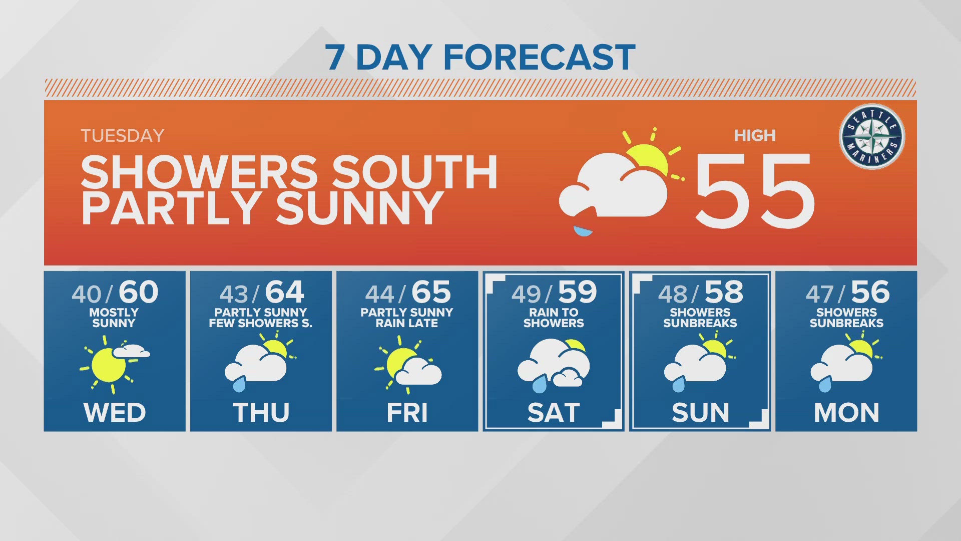
Tuesday: Showers mainly south Sound gradually dropping southward with clearing from the north during the day. Slight chance of a thunderstorm in the afternoon Olympia southward. becoming partly sunny during the afternoon. High temperatures in the mid-50s.
Wednesday: Mostly sunny and warmer. Chance of rain Wednesday night. Morning lows around 40 degrees. Highs in the upper 50s to lower 60s.
Thursday: A few showers mainly south in the morning clearing to partly sunny in the afternoon. Morning lows in the low to mid-40s. Highs in the low to mid-60s.
Friday: Partly sunny. Increasing chance of rain Friday night. Morning lows in low to mid-40s. Highs in the 60s.
Saturday: Rain early changing to off and on showers. Morning lows in the mid to upper 40s. High temperature in the low to mid-60s.
Sunday-Monday: Chance of showers mixed with sunbreaks. Morning lows in the mid-40s. Highs in the low to mid-60s.
Discussion:
Washington remains in an unsettled weather pattern with a series of weak weather systems pushing in from the northwest for a mixture of showers and sunshine on through the weekend and into next week!
An upper-level disturbance is brushing by just to the south of Puget Sound this morning for another round of showers with the heaviest mainly south of Tacoma. The showers will gradually end from the north today with clearing as the weather system drops farther south in the afternoon. However, there will still be a chance of showers and thunderstorms mainly Olympia southward in the afternoon.
A small area of high pressure will move through the state on Wednesday for a mostly sunny day with highs pushing up to near 60 degrees - close to the normal highs which are in the low 60s.
A more organized system moves in later Wednesday night with steady rain to start Thursday but it will turn to off-and-on showers during the morning - decreasing in the afternoon. Current models have it quickly dipping south as well.
High pressure will zip through during the day on Friday with highs warming into the mid-60s. However, a warm front spreads steady rain on Friday night for a mild but wet start to the weekend. Saturday morning will start wet early but change to off-and-on showers during the morning and those should end later Saturday.
An area of high pressure builds in later Saturday and moves through Sunday for a partly sunny day but rain may return Sunday night. It will be mild over the weekend with highs staying in the low to mid-60s.